Manaslu Trek
17 May 2019 whd
This is what it’s like to trek the mighty Manaslu Circuit
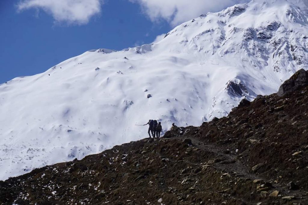
Troops of trekkers make their way up the gulley towards the precipice of Larke La, lethargy flooding their already languid legs.
“We are almost halfway,” one guide says. Halfway is not bad, everyone’s making good progress.
The monochromatic landscape is interrupted by flashes of color under headlamps, revealing fluorescent jackets in the distance. The day’s walk began at 4 am, under the safety of darkness and away from the slush-inducing sun. Gravity feels a lot stronger up here. With falling snow and a cloud-shrouded view of the horizon, the sun is slowly starting to pierce through the fog. It’s now barely 8 am, the snow is still structurally sound, and it’s morbidly silence.
“Halfway to the high point,” the guide says again, breaking the breathy quiet.
He means halfway to the viewing point of Larke La, which sits kilometers away at a lofty 5,160 meters. With at least another four hours from here until day’s end, morale drops as quickly as the temperature of our sweaty brows.
Huddled outside a snow-filled stone teahouse, groups of trekkers and guides have just one option: onward and upward. Leaning against boulders some 5,000 meters above sea level, just a couple of hours of hard toil is all that stands in the way of reaching the precipice. Putting weight on our feet once more, the rest is short lived and the trek must go on.
Pining for the forests of 48 hours ago, where the air was warm and soupy, Larke Pass is the only way to the next destination and the trail’s end. The preceding greenery seems worlds away, as a snowy day on Larke La is reminiscent of the moon. It’s eerily quiet, the only sounds coming from the squelch of fresh snow beneath boots.
The road to Larke La takes up to a week, depending on where one starts and how fast one beats the trail, while many trekkers take more than two weeks for the entire journey—for most, it ends in the Annapurna Conservation Area, at Dharapani, Manang. Including some acclimatization days, the trek is an exercise in extremes. It rates higher on the difficulty scale than the highways of the Annapurna and, while it’s not the highest pass in the country, it ranks among the more challenging. Unlike Annapurna Base Camp, this trail is not a destination. It’s a place where the trek itself is the destination, for between every step there is a different view.
Drizzled with white and stifled by clouds, mountains frame the entire journey; babbling, blue and loud, the Budhi Gandaki leads almost the entire way; sepia-toned and ragged, piles of mantra-carved slate and schist welcome walkers to every village.
Macchakhola, (930m)
Sitting below the dead end of the Manaslu Conservation Area’s drivable road, Maccha Khola is a sensible starting point for trekkers. Some start earlier, in Sotikhola, but the continuing construction of a road to China means there are fewer trails and the walk is essentially along a road.
Further north, approximately an hour’s walk and a bonafide river-crossing away, is Khorlabesi. Dodging slow-moving diggers and excavators, the road for the next few kilometres is littered with the remnants of explosives and rocks pried off the cliffs by Nepal’s army.
While the majority of the road on the western edge of the river is blanketed with ankle-mangling cliff debris, the trail eventually traverses the river on the first of the trail’s many suspension bridges. Once in more peaceful surrounds, the babbling Budhi Gandaki’s splendor is never far, while the construction sporadically interrupts the natural peace. At neck-bending heights, from man-made cliff crannies, boulders occasionally bomb off the cliff faces, dropping clusters into the river below.
The villages are set to benefit from the construction of this road, but until it is completed, in approximately 10 years, the brunt of freight is still being done with trains of mules and, higher up, various bovid creatures.
Nestled between cliffs, with the river guiding the way, when one reaches Yaruphant the claustrophobic climes fan out to briefly reveal the vibrant turquoise water snaking through vast beaches of stone. This idyllic spot is just 5km from where 2015’s earthquake first struck, and was ravaged at the time. By the time one reaches Jagat, a popular stay on the trail, the army’s work has all but subsided, and man’s footprint starts to dissipate into nature. The trail becomes naturally rugged and the bridges are reserved only for sole and hoof.
Philim (1570m) – Ghap (2050m)
The trail moves through lush green forests, small hamlets and over rocky terrain, while the shadow of the Himalayas is never far. Trekkers are few and far between, unlike the highways of the Annapurna, and the trails are rugged.
While there is not a lot of traffic, the brunt of jams come in the four-legged form. The villages get their most-needed goods, ones they cannot provide for themselves, from these long mule trains and sporadically, one can find truck stops full of the braying beasts. Most trekkers continue through Phillim, up to the sharp stinging nettle-lined trail, and onto another destination. The trains that rattle through the town are a good reminder of the realities of living in the Manaslu area—it’s a trek for those who don’t live here, but it’s par the course for the people living here. While trekkers take weeks to complete such a feat, it’s only a matter of days for fleet-footed train conductors and locals.
While not the most popular destination, Phillim is the administrative center for both the Manaslu Conservation Area and the rural municipality of Tsum Nubri. While many tourists lament the impact of a ventricle following the river to China—aesthetically and environmentally—the people welcome it with open arms. Leader of Tsum Nubri, Dhan Bahadur Gurung, says the road will be a practical and much-needed means to improve life in the village, given the problems with health care, subsistence farming and the cost of food. “People seem happy about the construction of the new road,” he says. In terms of the impact on tourism, however, he believes there will be a need for alternatives, given the road will essentially cover the trail up to Samdo. Once the road reaches the village near the Tibetan border, the circuit will be reduced to a less than four-day walk.
Just after Phillim, on the opposite side of the river to Nyak, one can find the junction for the increasingly popular Tsum Valley trek, which could potentially gain popularity once the road is finally built.
Ghap (2,050m) to Lho (3,180m)
Nestled atop a flat plain, covered in pastures studded yellow and white, the village of Ghap is where the area reveals itself as truly Tibetan dominated. A small chorten, with fading Buddha’s eyes painted on its front, is the formal welcome, while donkeys bathing in the dust provide a nice reminder of the capital. There are several relatively new teahouses on the river, and the area is experiencing more tourism, but the village remains sleepy.
Its European cousin could be the Jungfrau valley in Switzerland, but instead of lawn-topped roofs and perfectly paved roads, there are Buddhist sites and a foot-and-hoof-trodden track. Here is a good place to take revenge on the nettles that so often sting, as most places provide a mean sisnu jhol that is perfectly paired with a gut-filling wad of tsampa dhindo.
What does plague the area, however, is landslips. While most are completely fine and crossable, some provide rather sketchy circumstances for the unsure-footed. Given the vertical topography, the slips slow trekkers to a saunter in some spots, vertigo is a very real possibility.
Worth looking out for on the trail are the ever-changing bovine creatures that line the area. The jingling of their bells indicates they’re somewhere around, with their goat-like dexterity, but they come in a variety of breeds, colors, and combinations. One might find cows and buffalo in the lower regions, but the further north, the more yak-like they become. They are not all yaks, however. Some are joba, a long-horned woolly cow-yak hybrid; others are chauri, another Himalayan bovid blend. While it’s hard to tell the difference with an untrained eye, it’s good to know that yaks are the wooliest of the lot. With increasing elevation, their ears are decorated with dyed tufts of wool to signal ownership. They’re just as colorful as the flora, at the right time of the year. With the monsoon looming, pink, white, purple and red rhododendron flowers frame the valleys, while petals line the trails.
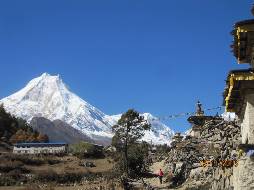
Lho (3,180m) – Namrung (2,660m) – Samagaun (3,525m)
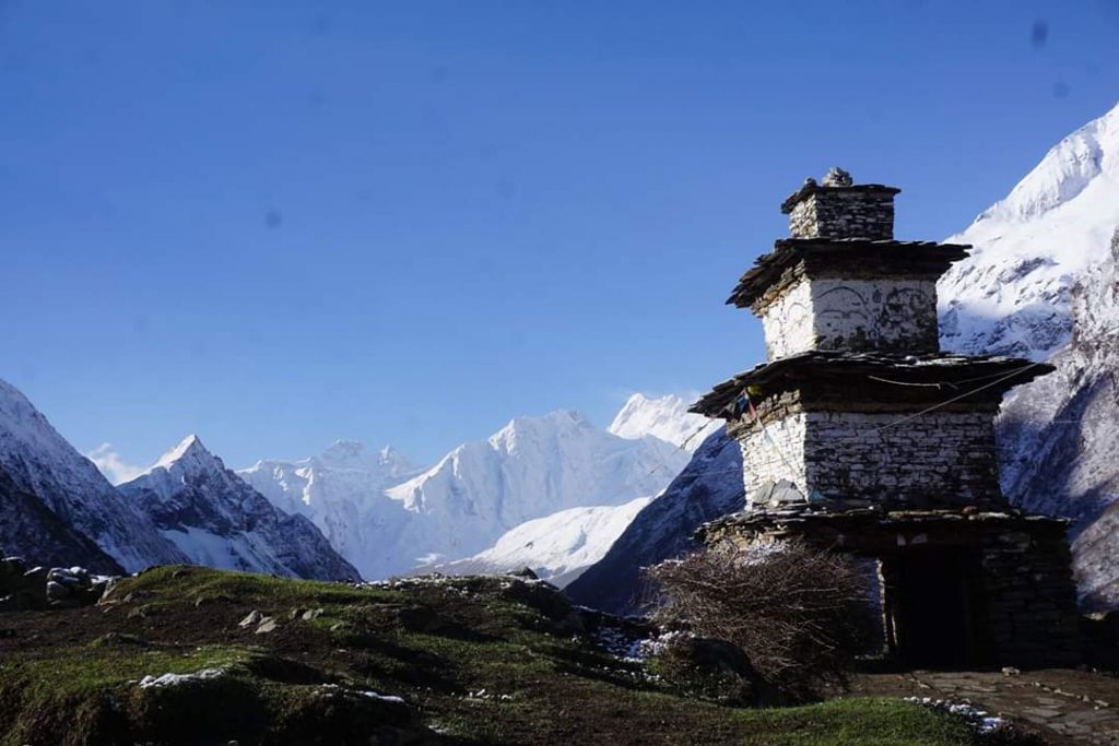
In Lho, the Gurung community’s firm grasp on the area is strongest. The water cascading from the cliffs are almost always close to villages, where it is harnessed for both electricity, through hydropower stations, and religion, through ingenious water-powered prayer wheels. Full of crows, this Winterfell-like stone village is one of the biggest in the higher parts of the circuit, and its main road runs brown with water from nearby farm irrigation.
Sitting above Lho, with a clear view of Manaslu, is Ribum Gompa. The Buddhist monastery provides a stunning view of the village below and is home to a transient group of young and old monks. Inside, one can find unbelievably intricate mandalas and thangkas, heavy metal statues of the Buddha and various deities, and pigeonholes laden with mantra texts wrapped in silk. While the area is deserted at this time of year, occasional soy candles flicker in prayer.
Further up the hill, from the monastic vantage point of Manaslu, the trail continues through the forest. While the trail up to this point was rocky, sandy and slip-laden, it now becomes softer, the air perfumed with bosque and mule droppings. Because of this forest, villages around these parts have some of the most wonderful wild mushroom dishes one can find in Nepal. In the tarkari form, they are perfect for soaking up spirals of sweet and yeasty tingmo buns.
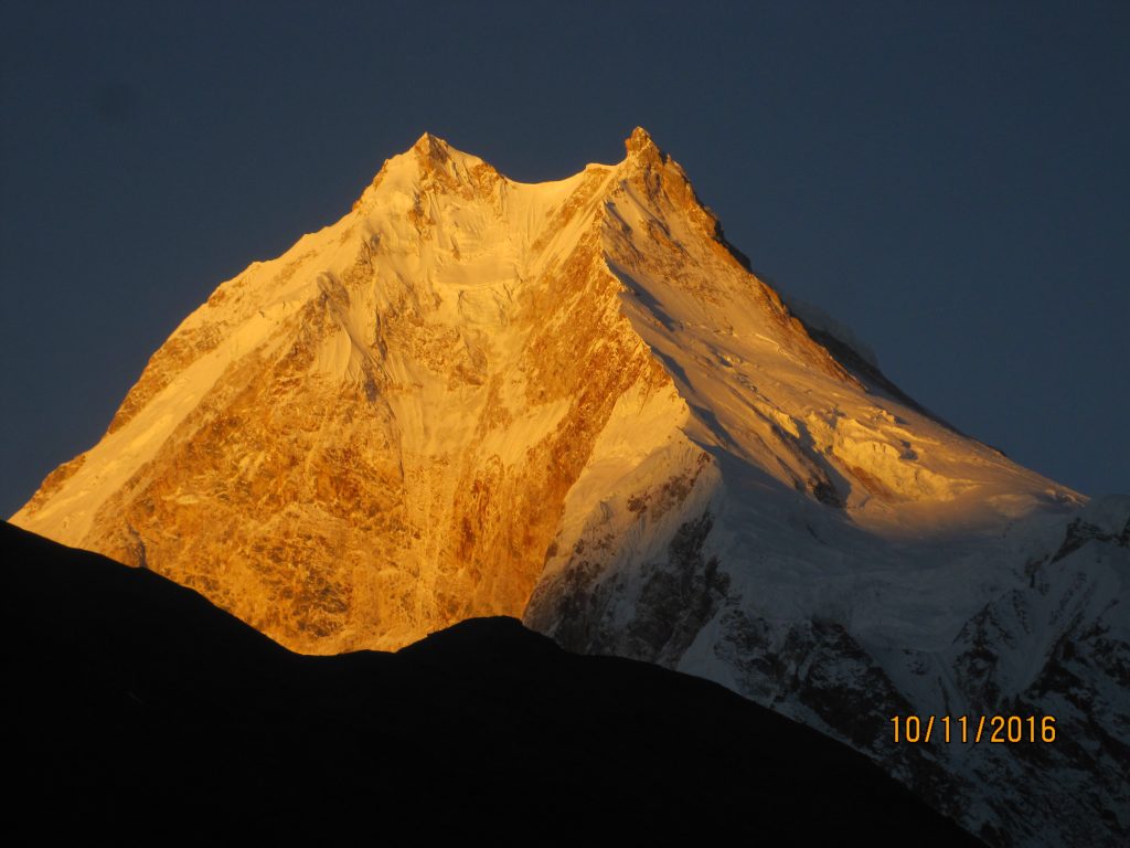
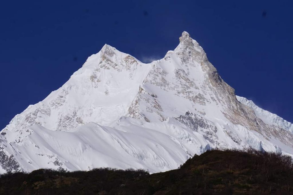
Giant boulders jut out of cliffs, providing precarious shade for the trail and a space for the prevalent Manokranti symbol. The upside-down spiralling question mark represents a self-help philosophical school of thought. While it’s a nice thought, it’s a rather unflattering symbol to tack onto an otherwise unsullied area—except for numerous Wai Wai packets. However, it’s hard to look down when the splendor of the Manaslu is standing over the trail.
The mountain, the eighth tallest in the world, is a whopping 8,163m. The highest point of the trek is a full three kilometers shorter, a crazy fact to think of while struggling up the comparatively stout hills. Despite its enormity, Manaslu was first summited in 1956 by a Japanese expedition. Given the difficulty and general endurance needed for this trek, it’s apt that Manaslu translates to “mountain of the spirit”.
Arriving in Namrung, however, one can find the peak of luxury available to trekkers in Manaslu, in the form of the Four Seasons. The technicolored oddity is the most luxurious spot on the trail, as is the place it sits in—Namrung, which even has, allegedly, its own pour-over coffee joint. While many stays here, and others stop for lunch, it’s the perfect place to try a rib-sticking thenthuk. Unlike thukpa, the more common noodle variation, thenthuk is made of fresh noodle dough. The dough, pulled by hand in haphazard shapes, thickens the soup and provides the perfect amount of stodge for the journey. The soup also provides a much-needed chance to consume fresh vegetables, which becomes harder to find, the higher one goes.
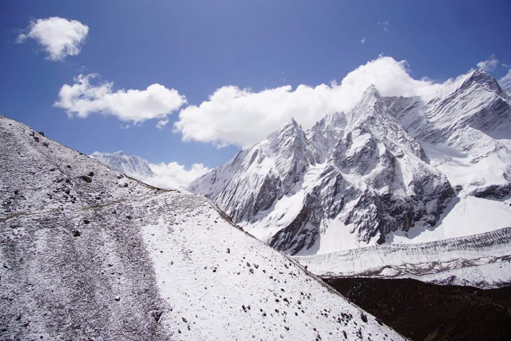
Before one arrives in Samagaun, stone-studded Shyala is the first panoramic welcome to the Himalayas. It’s where the mountains reveal themselves, unsullied by greenery, or anything for that matter. Manaslu guides the way, while enormous Pangboche, Thulagichuli, Himalchuli, and Chamar surround the town, reminding trekkers that despite being some 3,500m high, these mountains are another two to three kilometers higher.
Samagaun (3,525m) – Samdo (3,690m) – Dharmasala (4,470m)
The plains dividing the valley between Samagaun and Samdo follow the trail’s only constant: Budhi Gandaki. Providing some respite for those walking, the grassy plains are interrupted sporadically by distant jingling cattle and small chortens of carved slate. Not far from Samagaon is Birendra Tal, under Manaslu’s giant glacier. Its freezing teal waters are an attraction for most who stay here; it’s frozen ice boulders making for a frigid playground that reduces grown adults to children. This lake feeds east into the Budhi Gandaki, which, once again, follows north to the hilltop village of Samdo.
The penultimate stop before Larke La, Samdo is a stone’s throw from the Tibetan border. While many make the journey to the border on an acclimatization day, the surrounding area of Samdo is well worth exploring. Up to the hill, at a small chorten, unparalleled views of the area can be had, the village’s stone-roofed homes resemble lizard skin, even as their insignificance is amplified by the enormity of Manaslu, nature’s constant reminder of human impotence. Towards Samdo Himal, marmots run underground and pop their heads up for those with a keen eye, while herds of blue sheep fossick in search of wild herbs and flowers.
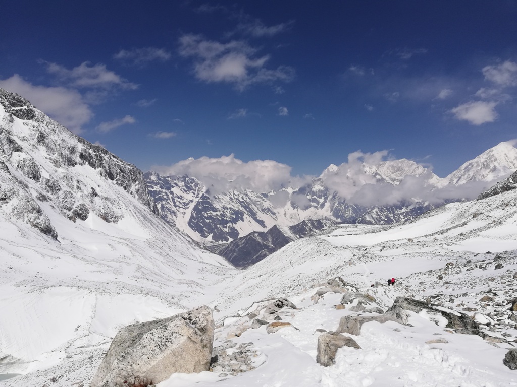
Dharamsala (4,470m) – Larke La (5,160m) – Bhimtang (3,800m)
By the time one reaches Larke La, the enormity of the space-like place is evident. Some may be hazy from the effects of the thin air, gasping for oxygen, others filled with sluggishness from the slushy later leg of the journey. Despite moving up just 690m, each step feels twice as heavy with the weight of thin air. To imagine this 5,160m massif is still dwarfed by the surrounding mountains is unbelievable. Following the seasoned porters and guides, the path is hinted at by near-immersed snow depth markers. Black metal poles stick out amidst the now tri-color landscape, but the incredibility of the peaks around direct you to the empty space at the end of the pass.
As the snowy squelch of feet turns to wet footsteps, those who’ve come prepared—wearing crampons—make swift work of the 1,550m descent from the pass, but others slip and slide their way down the knee-crushing journey. While the hardest part of the trek should, in essence, be over, the downward journey is equally arduous. Dropping some 800m from the pass, two teahouses welcome weary walkers with piping hot chiya and snacks, but there is still a two-hour journey awaiting them to get to the touristy village of Bhimtang.
The village sits in the middle of a wind-tunnel valley, and so does not provide warm respite. But it does have incredible views of the Himalayas. Despite a grass meadow filling the space between cliffs, there is no agriculture. The sight of Bhimtang is welcoming, where rocks assemble on the plains in the form of hotels and teahouses. The town does not exist without trekkers, so depending on the state of the pass, it can either be desolate or laden. It’s the final goodbye for trekkers, who make their way back onto the roads and freeways of the Annapurna Conservation Area.
By the time snow and slush have consistently turned to dirt, the mule and bovine trains steadily reappear. Some conductors ride their freight, others whip them into submission. Their jingles are a distant reminder of the long journey on the other side of Manaslu Himal. Legs still languid, lethargic from the day’s trekking, trekkers are welcomed by flowers and delicious, warm, soupy air.