


Climbing Mount Everest is a highly challenging and dangerous endeavor, attracting adventurers, mountaineers, and climbers from around the world. The world's highest peak stands at 8,848.86 meters (29,031.7 feet) above sea level and is located on the border between Nepal and the Tibet Autonomous Region of China. The climb is considered a significant achievement for mountaineers, but it is fraught with risks.
Here’s a general overview of the climbing process:
1. Preparing for the Climb
- Physical Training: Aspiring climbers must undergo rigorous physical and mental training. This includes building strength, stamina, and mental resilience to handle extreme conditions.
- Experience: Most climbers have experience on other high-altitude mountains (usually 6,000–7,000 meters) before attempting Everest. Having experience in technical mountaineering and an understanding of ice, rock climbing, and altitude sickness is essential.
- Expedition Team: Most climbers join commercial expeditions that provide support from guides, sherpas, cooks, and other team members. These expeditions typically offer the necessary equipment, oxygen tanks, and logistics.
2. The Climbing Route
The most common route for climbing Everest is the South Col Route (Nepal side), while the North Col Route (Tibet side) is also used.
- South Col Route: The ascent begins at the base camp (5,380 meters) on the southern side of the mountain in Nepal. Climbers move up through various camps:
- Base Camp (5,380 meters): The starting point of the journey.
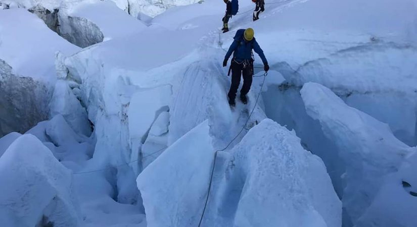
- Camp 1 (6,065 meters): Located at the top of the Khumbu Icefall, a treacherous section with huge blocks of ice and crevasses.
- Camp 2 (6,400 meters): At the foot of the Lhotse Face, a steep and ice-covered section.
- Camp 3 (7,200 meters): Located on the Lhotse Face, an exposed and challenging area.
- Camp 4 (7,900 meters): The final camp before the summit push, located near the South Col.
- Summit Push (8,848 meters): The final ascent is typically done early in the morning, and climbers try to summit during a small window when weather conditions are most favorable, usually in May.
- North Col Route: Starts from Tibet, with a similar sequence of camps but slightly different terrain.
3. Challenges
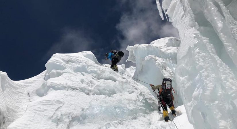
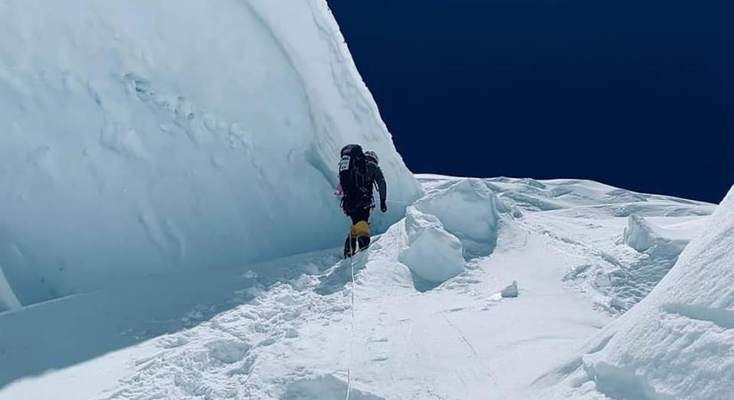
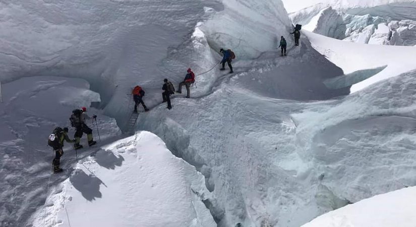
- Altitude and Oxygen: The primary challenge is the extreme altitude. Above 8,000 meters, known as the "Death Zone," the oxygen levels are so low that climbers must use supplemental oxygen to avoid altitude sickness and exhaustion.
- Weather: Mount Everest's weather is extremely unpredictable, with freezing temperatures, powerful winds, and sudden storms. These conditions make the ascent perilous.
- Physical and Mental Strain: The thin air leads to fatigue, and hypoxia (lack of oxygen) can impair decision-making. Additionally, climbers are at risk of frostbite, exhaustion, and dehydration.
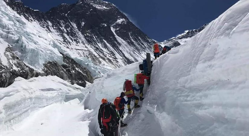
- The Khumbu Icefall and the Hillary Step: The Khumbu Icefall, with its massive ice seracs and crevasses, is a major obstacle. The Hillary Step, a nearly vertical rock section near the summit, is another notorious challenge.
- Crowds and Delays: In recent years, Everest has seen an increase in the number of climbers, leading to congestion on the route and delays. This can be dangerous, especially when weather windows are limited.
4. Summit and Descent
- Once on the summit, climbers typically spend only a short amount of time at the top due to the harsh conditions and the need to descend quickly. Some climbers wait for a window of good weather before making their final push.
- The descent is as dangerous as the ascent, with many accidents occurring during the return journey, often due to fatigue, weather changes, or unexpected mishaps.
5. The Role of Sherpas
Sherpas are essential to Everest expeditions. They are experienced mountaineers from the local Sherpa community and help guide climbers, carry loads, set up camps, and assist with difficult sections of the climb. Their local knowledge and expertise are invaluable for safely navigating the mountain.
6. Costs
Climbing Mount Everest is expensive, with the cost typically ranging from $30,000 to $100,000 or more, depending on the type of expedition, the level of support, and the services provided. This includes permits, guides, Sherpas, equipment, and logistics.
7. Risks
Despite its allure, Everest is a deadly mountain. Over 300 people have died attempting to climb it. Some of the common causes of death include altitude sickness, falls, avalanches, exposure, and exhaustion. The bodies of some climbers remain on the mountain, often serving as grim reminders of the dangers of the climb.

Trip Outline
Day 01: Fly to Lukla & Trek to Phakding - 2,840m/9,315ft
Day 02: Trek to Namche Bazar
Day 03: At leisure in Namche Bazar
Day 04: Trek to Tangboche
Day 05: Trek to Dingboche
Day 06: Acclimatization
Day 07: Trek to Lobuche
Day 08: Trek to Everest Base Camp.
Day 09-18: Rest and preparation
Day 18-38: Ascent of Mt Everest
Day 57: Trek to Lukla
Day 58: Fly Lukla to Kathmandu
Detail itinerary
Day 1 Fly to Lukla and trek to Phakding
4 Hrs B / L / D Tea House
Take a mesmerizing flight to Lukla (2800m) from Kathmandu as you overlook a beautiful landscape of snow-capped mountains. Upon reaching, start your trek to Phakding, a beautiful town in Sherpa Village at the altitude of 2610m. It is a pleasant walk of 9km (5.6 mi.) and takes 3 hrs. You’ll pass many colourful Tibetan Buddhist prayer walls, monasteries, and monuments. Stop for tea and lunch in one of the intermediate villages on your way. Upon arrival at Phakding, check into your room and spend the afternoon relaxing, giving your body ample time to acclimatize. Make sure to keep yourself well-hydrated. Drinking 4 to 5 litres of water a day is essential throughout the entire trek.
Day 2 Trek to Namche bazaar
7 Hrs B / L / D Tea House
After a nice, hot breakfast, start your trek to the town of Namche via Toktok, Benkar, Monjo and Jorsalle. For the first couple of hours, you will cross some of the famous suspension bridges. This will be on your way uphill to the Sagarmatha National Park, the official entrance to the Everest Region. From there, you briefly continue downhill till it levels out to a ground of mixed terrain. The trail then follows the river to the final high suspension bridge. Thereon, you begin the long ‘Namche Hill’ trek. You’ll reach the Sherpa village of Namche Bazaar after 2 more hours of trekking. The itinerary has you based in Namche Bazaar for 2 nights at 3,340m / 11,286 ft. Today, you’ll cover 14 km (5 mi.) in 5-6 hours with plenty of breaks to rest along the way. The trail is quite challenging at places, as it holds several exposed parts. You’ll have to tread carefully, but the efforts will be rewarding because of the scenery!
Day 3 Acclimatization day at Namche bazaar
3 Hrs B / L / D Tea House
Acclimatization is crucial on this trek to avoid AMS further up the trail. So, indulge in light activities like hiking up to the Everest View Hotel for spectacular views or walking to the twin Sherpa Villages, Khumjung and Khunde. You can also stroll around the Namche Bazar town and visit the Sherpa Museum. The market is full of restaurants and bars along with cyber cafes, souvenir shops and grocery stores, making it a nice place to hang around.
Day 4 Trek to Tangboche
7 Hrs B / L / D Tea House
Hike towards Tengboche, situated at an altitude of 3870 m. After the first 20 minutes of hiking uphill, you’ll be presented with an eye-pleasing trail for the next 1.5 hrs, till you reach Kyanjuma. Further, the trail drops down to the Dudh Kosi River. You cross it with a suspension bridge at Phungitenga. The water-driven prayer wheel resting here is quite an amusing sight to marvel at. Upon reaching Phungi Thangna, refuel yourself with a fulfilling lunch and adequate rest. From here, you’ll be hiking up the hill town of Tengboche over a period of 3 hrs. This is a gradual but long ascent, leading up to 5-6 hours of total trekking for the day. Further, you’ll reach the destination for the day, Namche Bazar. Explore the region’s most active Buddhist Monastery in the evening and then visit the sacred land exhibition centre. You’ll be amidst the most stunning views of the mountains. To add to it, you’ll be watching a beautiful sunrise and sunset
Day 5 Trek to Dingboche
7 Hrs B / L / D Tea House
Trail is full of mesmerizing experiences. It takes you through the Rhododendron fields, birch and blue-pine forests. This will continue for the next two hours until you reach the suspension bridge. After crossing the bridge, the climb up a gently steep trail begins, ending in the Pangboche village. After a lunch break at Somare, continue walking through isolated pastures and fields on the trail towards Orsho. From there, head towards Dingboche, following the upstream trail of Imja Khola. After two hours of witnessing beautiful Today’s landscapes, you’ll arrive at Dingboche. From here, you’ll get to marvel at the Amadablam, Island Peak, Lhotse, Tawache, Tsolache, Lobuche, and other peaks as you settle in for a good night’s sleep.
Day 6 Acclimatization day
4 Hrs B / L / D Tea House
Now that you’ve reached the height of a whopping 4410m, give your body a day to rest and acclimatize with the weather here. If you’re not big on lazing around, you have the choice of going for an acclimatization trek to the Nagarjuna Peak (5030 m), which takes nearly 3 hrs. Enjoy the views and then come back down for lunch and siesta. Alternatively, you can hike to Nangkar Tshang (5616 m). This will be more demanding physically but will reward you with stunning views of the Mt Makalu and other surrounding peaks.
Day 7 Trek to Labuche
7 Hrs B / L / D Tea House
Begin your day with a short climb to the ridge upwards of Dingboche. Carry on with the short Chhorten trail that takes you through a grassy moraine above the Khumbu Khola Valley, until you reach Thukla. Here, you’ll get a glimpse of the majestic peaks of Pumori, Nuptse, Lobuche, Cholatse, Tawache, Amadablam, along with other small peaks.
Day 8 Trek to Everest Base camp (5360m) and then trek to Gorekshep
6 Hrs B / L / D Tea House / Tent
It’s the day you’ve been looking forward to for the past week! After a filling breakfast, continue your trek on the left bank of the Khumbu Glacier. Undertake the steep climb up to the Changri Glacier, followed by a short descent to reach the Gorakshep. This will take you around 2.5 hrs. Upon reaching, have freshly prepared lunch. Now, flutter with excitement as you’ll be hiking up to the Everest Base Camp! It’s a 10 km (6.2 mi.) hike to the destination you’ve dreamt of for months if not years. Watch the sun go down between the snow-capped Himalayas, as you look up and marvel at Nature’s true wonder, the mighty Mt Everest! That’s what we call ‘ending the day on a high.
Day 9 - 18 Rest and preparation
B / L / D Tent
Rest and preparation
Day 19 - 38 The Ascent of Mt Everest
B / L / D Tent
Ascent of Mt Everest
What's included?
- All domestic flights.
- Climbing Equipment
- All governmental procedure fees, all permits and local taxes.
- All meals and accommodation throughout the trek.
- Climbing Equipment
- An experienced English speaking trekking guide / Climbing Guide possessing valid license issued by the government of Nepal.
- Highly experienced trekking staffs.
- Travel and rescue arrangements.
What's not included?
- Visa fees/ international airfare to and from Kathmandu
- Travel / medical insurance and emergency evacuation cost.
- Hot and cold shower, battery recharge during the trek.
- Personal expenses phone calls, bar bills, extra porters, beverages etc.
- Personal Everest base camp trekking equipments/gears.
- Tips for guides, porters
- All others expenses not mentioned in “Trip Cost Includes” section.
- Costs incurred due to unforeseen reasons like general strikes, accidents, unavailability of tickets (see Disclaimer above) or any event beyond the control of the company
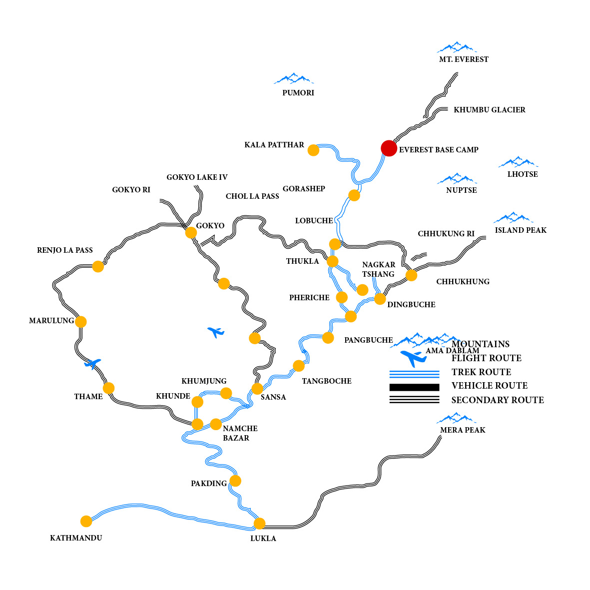
Elevation Chart & Map