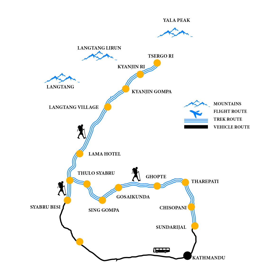


The Langtang Valley Trek is one of Nepal's most popular trekking routes, located just north of Kathmandu, close to the Tibetan border. It is known for its stunning landscapes, unique cultural experiences, and relatively accessible difficulty level, making it ideal for trekkers of various abilities.

Key Highlights
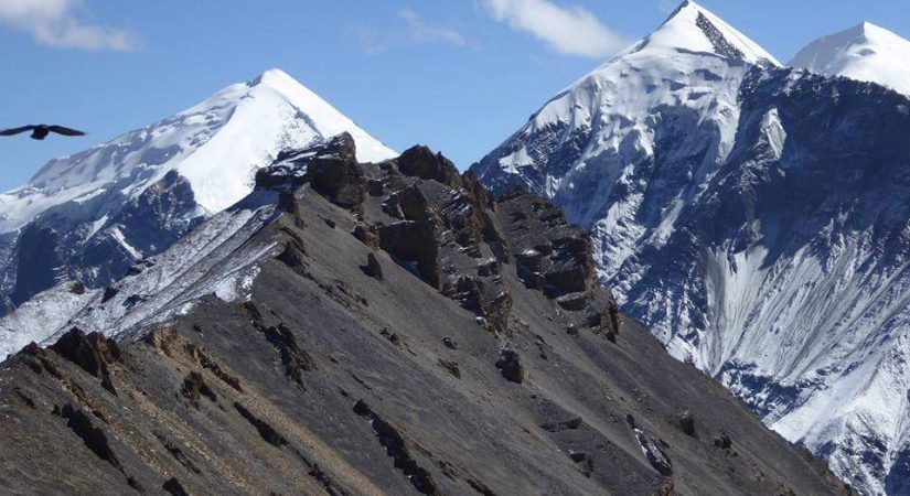
- Scenic Views: The trek offers breathtaking views of peaks like Langtang Lirung (7,227 meters), Ganesh Himal, and several other snow-capped peaks. You'll also experience magnificent forests, waterfalls, and valleys.
- Cultural Experience: The Langtang region is home to Tamang and Sherpa communities, and the trek offers a unique opportunity to experience their lifestyle, culture, and traditions. The Tibetan influence is strong in this area.
- Langtang National Park: The trek takes you through Langtang National Park, a haven for diverse flora and fauna. You may encounter wildlife such as red pandas, Himalayan tahr, and various bird species.
- Kyanjin Gompa: A major highlight of the trek is the ancient Kyanjin Gompa (monastery), around 3,800 meters. The surrounding views are spectacular, with glaciers and towering peaks.
Key Trekking Points
- Syabrubesi: The starting point of the trek, a small town with basic accommodations and a gateway to the Langtang Valley.
- Lama Hotel: A popular stop on the way, offering a place to rest with beautiful surroundings.
- Langtang Village: One of the largest villages in the valley, known for its picturesque views and Tamang culture.
- Kyanjin Gompa: The final destination with a Buddhist monastery and several hiking options.
- Kyanjin Ri & Tsergo Ri: Popular viewpoints that offer panoramic views of the Langtang range.
Challenges
- Altitude: Although the Langtang Valley Trek doesn't go as high as some other treks in Nepal (like Everest or Annapurna), the altitude can still cause altitude sickness. It's important to take adequate rest and acclimatize properly.
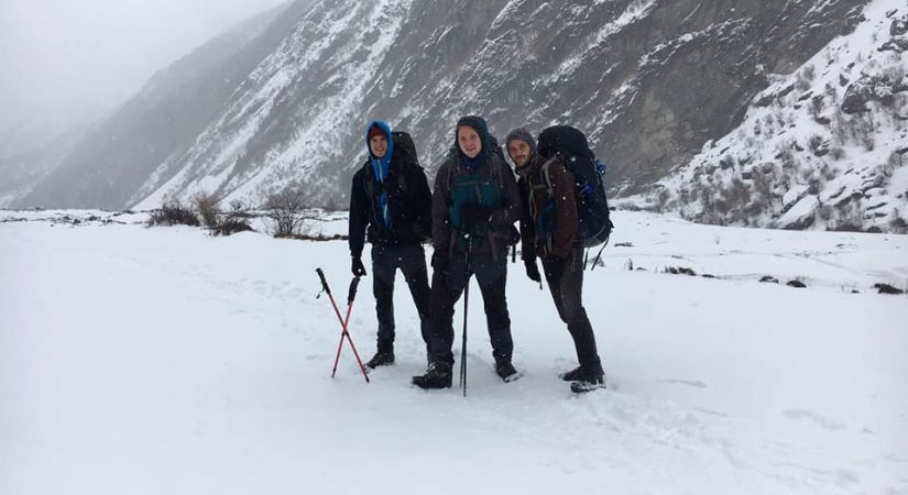
- Weather: Weather can be unpredictable, with cold temperatures at higher elevations, especially in the winter months. Be prepared for snow or rain, particularly in the spring and autumn.
- Physical Endurance: The trek involves steep ascents, especially as you approach Kyanjin Gompa and beyond. Having a good level of fitness is important.

Permits Required
- Langtang National Park Permit: Required for entry into the Langtang region.
- TIMS (Trekkers' Information Management System) Card: A mandatory permit for all trekkers in Nepal.
Trip Outline
Detail itinerary
Day 01: Drive to Syabru Besi by local Jeep or Deluxe Bus
6 Hrs B/L/D Lodge
To Syabrubesi (1,467m) – about 8 hours: This morning, we drive from Kathmandu to Syabrubesi (1,467m) by bus. Leaving Kathmandu, we head north through scenic foothills and ridgeline vistas to Dhunche, the main trading post in the region, and then on to Syabru Besi. While passing beside the picturesque Trisuli River, we catch our first glimpse of Ganesh Himal (Ganesh mountain range – a sub range of the Himalayas) towering over terraces and green hills.
Day 02: Trek to Lama Hotel
5 Hrs B/L/D Tea House
To Lama Hotel (2,470m) – about 5 to 6 hours: After a meal, good night’s sleep and breakfast, it’s time to begin trekking. The trail today is mostly beside the Langtang River, and passes through fir and rhododendron forests. We make several river crossings on suspension bridges. Watch out for red pandas, monkeys and bears if we are lucky.
Day 03: Trek to Langtang village
5 Hrs B/L/D Tea House
To Langtang village (3,430m) – about 5 to 6 hours: Today we ascend via Ghore Tabela over 1000 meters, and as the altitude increases, so the vegetation becomes thinner and with fewer trees. Our destination Langtang is a typical Tibetan style village
Day 04: Trek to kyanjyang Gompa
5 Hrs B/L/D Tea House
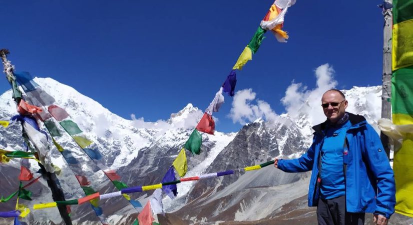
On the third day we set the biggest challenge for ourselves: to climb up to the Kyanjin Ri viewpoint that we had seen looming over the village the previous couple of days. Several paths led towards the viewpoint, and we started very motivated. The path wound higher and higher, and got steeper and steeper. When we were there it hadn’t rained for many days and the conditions were very good, but I would not want to climb that path after rain, or even snowfall.
After a climb that seemed much longer than it actually was (and some heart-stopping moments when my daughter stood at the edge of a 100 metre drop!) we arrived at the first viewpoint. In a sea of prayer flags a couple of benches were placed–the perfect spot for a small break. The view from here was already spectacular, and the village down in the valley looked like a toy village. We could see far down the valley, and Tibet seemed only a stone’s throw away.
After a quick snack we continued along the ridge to reach the second view point further up. The ascent was quite scary – the ridge dropped vertically to the left and still quite steeply to the right side. Nevertheless, we climbed at an ant’s crawl and around 45 minutes later we stood on the Kyanjin Ri viewpoint, at 4600 metres. From there we could see the glacier and lake again, but this time from the top. We stayed a long time taking in this amazing view, with only the sound of prayer flags flapping in the wind.
Day 05: Rest day/Exploration day
4 Hrs B/L/D Tea House
To climb up to the Kyanjin Ri viewpoint that we had seen looming over the village the previous couple of days. Several paths led towards the viewpoint, and we started very motivated. The path wound higher and higher, and got steeper and steeper. When we were there it hadn’t rained for many days and the conditions were very good, but I would not want to climb that path after rain, or even snowfall.
After a climb that seemed much longer than it actually was (and some heart-stopping moments when my daughter stood at the edge of a 100 metre drop!) we arrived at the first viewpoint. In a sea of prayer flags a couple of benches were placed–the perfect spot for a small break. The view from here was already spectacular, and the village down in the valley looked like a toy village. We could see far down the valley, and Tibet seemed only a stone’s throw away.
Day 06: Trek back to Lama Hotel
6 Hrs B/L/D Tea House
Day 07: Trek to Thulo Syabru Besi
6 Hrs B/L/d Tea House
Day 08: Back to Kathmandu by Bus
5 Hrs B/L
What's included?
- Trekker’s Information Management System(TIMS) card
- All governmental procedure fees, permits and local taxes.
- All meals and accommodation throughout the trek.
- An experienced English speaking trekking guide possessing valid license issued by the government of Nepal.
- Highly experienced trekking staffs.
- Travel and rescue arrangements.
What's not included?
- Visa fees/ international airfare to and from Kathmandu
- Travel / medical insurance and emergency evacuation cost.
- Hot and cold shower, battery recharge during Everest base camp trek.
- Personal expenses phone calls, bar bills, extra porters, beverages etc.
- Personal Everest base camp trekking equipments/gears.
- Tips for guides, porters and drivers.
- All others expenses not mentioned in “Trip Cost Includes” section.
Elevation Chart & Map