


Island Peak, also known as Imja Tse (6,189 meters or 20,305 feet), is a popular trekking and climbing peak located in the Khumbu region of Nepal, near the Everest Massif. It is one of the most sought-after trekking peaks in Nepal, often chosen by mountaineers as a stepping stone before attempting higher mountains like Mount Everest.
Island Peak has become a popular destination for adventurous trekkers and mountaineers who want to experience a Himalayan climb without the extreme difficulties of larger peaks. It's also a key destination for those aiming to build their mountaineering skills before taking on higher and more demanding climbs.
Key Features of Island Peak:
- Location: Island Peak lies in the Sagarmatha National Park, part of the Himalayas in eastern Nepal, and offers stunning views of the surrounding peaks, including Mount Everest (8,848 meters), Lhotse (8,516 meters), and Ama Dablam (6,812 meters).
- Climbing History: The peak was first ascended in 1953 by a British expedition as part of their preparation for the first successful ascent of Mount Everest. The name "Island Peak" was given due to its appearance; from a distance, it resembles an island rising above the surrounding glaciers.
- Trekking Peak: Island Peak is classified as a trekking peak by the Nepal Mountaineering Association (NMA), meaning it is open to climbers with limited experience, provided they have basic mountaineering skills. It does not require technical expertise at the level of higher peaks like Everest, but climbers need to be prepared for snow, ice, and steep rock sections.
- Climbing Route: The standard route to the summit involves a long approach trek from Lukla, through Namche Bazaar, Tengboche, and Pangboche, before reaching Chhukhung, where the ascent begins. From there, climbers cross glaciers and ascend through steep sections using fixed ropes, ice axes, and crampons.
- Summit: The final summit push requires ascending a steep snow and ice slope, with a ridge leading to the top. The summit offers panoramic views of the surrounding mountains, including the Everest and Lhotse massifs.
- Challenges: The challenges on Island Peak include high-altitude effects (above 6,000 meters), technical climbing on snow and ice, and unpredictable weather conditions, which can create risks, such as avalanches or sudden storms.
Trip Outline
Day 01: Fly to Lukla (2,800m/9,184ft) then trek to Phakding (2,652m/8,700ft): 40 min flight, 3-4 hours trek
Day 02: Phakding to Namche Bazaar (3,440m/11,283ft): 5-6 hours
Day 03: Namche Bazaar (3,440 m/11,283 ft): Acclimatization Day
Day 04: Namche Bazaar to Tengboche/Debuche (3,870m/12,694ft): 5- 6 hours
Day 05: Tengboche to Pheriche (4,200m/13,776ft): 4-5 hours
Day 06: Pheriche to Lobuche (4,930m/16,170ft): 5-6 hours
Day 07: Lobuche to Everest Base Camp (5364m/17,594ft) and back to Gorak Shep (5170 m/16,961ft): 6-7 hours
Day 08: Gorak Shep to Kala Patthar (5545m/18,192ft] and back to Dinboche (4940m/16,207ft): 7-8 hours
Day 09: Dinbuche to Chhukung (4,730m/15,518ft): 3-4hrs, Chhukung instead. Included meals:
Day 10: Chhukung to Island Peak Base camp (5,200m/17,060ft): 3-4 hours
Day 11: Pre-Climb Training on Island Peak Base Camp
Day 12: Island Peak Base Camp to Summit and Chhukung (4,730m/15,518ft):) 12-14 hours
Day 13: Chhukung (4,730m/15,518ft): Namche Bazaar (3,440m/11,286ft): 6-7 hours
Day 14: Trek to Lukla
Day 15: Fly to kathmandu
Detail itinerary
Day 01: Fly to Lukla (2,800m/9,184ft) then trek to Phakding
4 Hrs B/L/D Tea House
We head to Tribhuvan International Airport for an early morning flight to Lukla. After a scenic 40 minutes flight, you will land at the Tenzing Hillary Airport at Lukla. Our trek begins from the prosperous village of Lukla and reaches Phakding. Today's trek will be short and enjoyable as you will also be acclimatizing. With spare time on your hands, you can visit the local monasteries around Phakding and prepare yourself for the long trek the next day.
Day 02: Phakding to Namche Bazaar (3,440m/11,283ft)
6 Hrs B/L/D Tea House
We begin the six-hour trek along the banks of the Dudh Kosi, crossing several tributaries of this majestic river many times on thrilling suspension bridges adorned with prayer flags. After entering Sagamartha National Park, the trail climbs steeply, providing you with breathtaking views. Namche Bazaar, known as the “Gateway to Everest,” is home to several quality restaurants, hotels, lodges, internet cafes, shops, and a bakery. Namche (3441m) is one of the biggest towns along the Everest trail.
Day 03: Namche Bazaar (3,440 m/11,283 ft): Acclimatization Day
4 Hrs B/L/D Tea House
We will spend a day at Namche to adjust to the high altitude. You should not miss visiting the Sherpa museum celebrating Sherpa traditional customs. Further, we will hike to the Syangboche Airport and the Everest View Hotel. From Everest View Hotel, you can see rewarding views of the Himalayas (including Everest) with a stunning sunrise and sunset over the panorama of Khumbu peaks.
Day 04: Namche Bazaar to Tengboche/Debuche (3,870m/12,694ft)
6 Hrs B/L/D Tea House
After our early morning breakfast, we will begin our trek to Tengboche. On the way, we will enjoy the stunning views of Mt. Everest, Nuptse, Lhotse, and Island peak. The trail leads us up and down as it becomes challenging, but you’ll enjoy great views of the Himalayas. You may also spot wildlife on the way, such as musk deer, pheasant, and Himalayan tahr. We will further trek down to cross the Dudh Koshi River. After passing through dense alpine forests, you will reach a small settlement called Phunki Thenga. As you trek ahead from Phunki Thenga, you will eventually get to Tengboche after a steep climb through a pine forest. In Tengboche, you will see the biggest Buddhist monastery in the Khumbu Region - Tengboche Monastery.
Day 05: Tengboche to Pheriche (4,200m/13,776ft)
5 Hrs B/L/D Tea House
We continue trekking uphill to Pangboche, past many chortens, mani walls, and small villages. You can see spectacular views of the Mt. Island peak from the trails. You will be entering the Imja Valley following the Lobuche River and trek on a steeply ascending trail to Dingboche. From Dingboche, we can see the Island peak (6,812m) and Mt. Lhotse (8,516m).
Day 06: Pheriche to Lobuche (4,930m/16,170ft)
6 Hrs B/L/D Tea House
Lobuche is the most technically difficult summit in the Everest area. The hike to Lobuche East Peak takes 5-6 hours, and the day of the summit takes 8-10 hours. The path from Lobuche hamlet to Lobuche Base Camp is steep, rocky, and exhausting. Leaving Pheriche the trail heads up the drainage of the Khumbu across a fairly level wind swept outwash plain. After about an hour it starts to climb steeply up the terminal moraine of the Khumbu Glacier. Halfway up the moraine is Dughla a small tea collection of guest houses where you can break for coffee or tea. Continuing on past Dughla the trail continue to climb steeply to the top of the morraine where a memorial has been placed for climbers who died on Everest. The trail now continues on fairly level on the west side of the lateral moraine before reaching Lobuche.
Day 07: Lobuche to Everest Base Camp (5364m/17,594ft) and back to Gorak Shep (5170 m/16,961ft)
7 Hrs B/L/D Tea House
At Thangma Riju, one can experience the 360-degree panoramic view of snowcapped mountains. Unfortunately, we cannot see Mount Everest from here. However, We can view Mount Nuptse, Mount Nuptse, and Mount Pumori. Below Mount Pumori, we see a grey grassy land of Kalopaththar after climbing up the steep terrain of Changri glacier.
Day 08: Gorak Shep to Kala Patthar (5545m/18,192ft] and back to Dinboche (4940m/16,207ft)
8 Hrs B/L/D Tea House
We start early today to witness a glimpse of Mount Everest when the dusk turns to a bright morning with the light of the day. Peaks like Lingtren, Khumbutse, and Changtse, are viewed on the way. Next, we suggest that during the ascent to Kalapththar, which takes hours, one pauses and catches one breath while snapping the photos at times. Then, finally, we descend back to Dinboche , where we stay overnight.
Day 09: Dinbuche to Chhukung (4,730m/15,518ft): 3-4hrs, Chhukung instead. I
4 Hrs B/L/D Tea House
Adding on Chukhung (also spelled Chhukhung) to your itinerary, will give you the chance to experience an area that most do not get to see. Not only will you have the chance to head over the Kongma La Pass to Lobuche, but you also can head on hikes to Island Peak Base Camp as well as a hike up Chukhung Ri. During my trip taking part of the entire Three Passes Trek, I headed to Chukhung on day 7, checked into my teahouse, and then did the round trip hike to Island Peak Base Camp that afternoon.
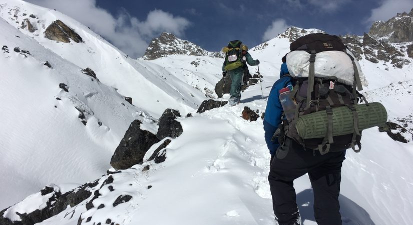
Day 10: Chhukung to Island Peak Base camp (5,200m/17,060ft)
4 Hrs B/L/D Tent
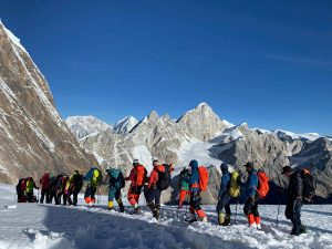
Starting from the Chhukung valley, we will head towards the Base Camp today. From an altitude of 4750 meters, we shall head towards an altitude of 5200 meters at the Island Peak Base Camp. he trekking trails from Chhukung to Island Peak Base Camp are steep and rocky. On your way to the Island Peak Base Camp, you can see the beautiful glaciers. Passing through the Imja River to the Lhotse Glacier, you can explore the magnificent and mesmerizing views of the neighboring mountains along with the beautiful glaciers. Take your time with short breaks in between and mind your step as the rocky steps may be slippery in some parts. You will be spending the night at the base camp in tented camps. You will be provided with a kitchen crew and nutritious food.
Day 11: Pre-Climb Training on Island Peak Base Camp
3 Hrs B/L/D Tent
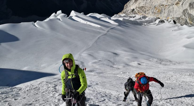
We begin our pre-climb training today after breakfast. Our guides will provide training on peak climbing techniques and the proper ways of using climbing gears such as the ice axe, climbing boots and crampons, harness, ascender, etc. The training will also include using ropes to go up and down. Although it is not mandatory to have prior training for Island Peak Climbing, we strongly believe that some training experience will boost your confidence and climbing skills to increase the chances of scaling the summit as well as to fully enjoy the experience. We can spend the rest of the day hiking to high camp and back or resting for the next day’s climb
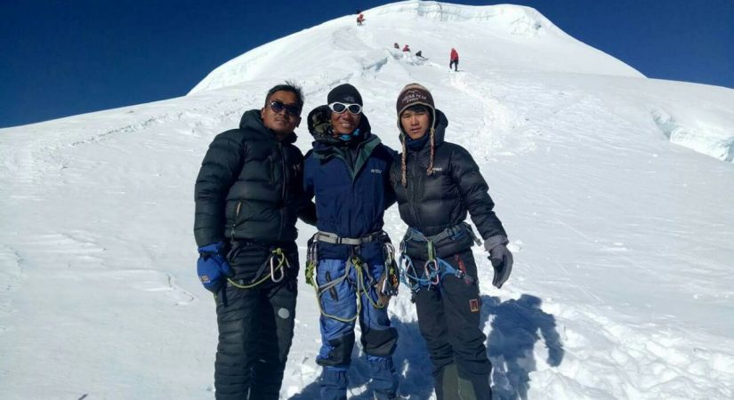
Day 12: Island Peak Base Camp to Summit and Chhukung
14 Hrs B/L/D Tea House
You get your stuff and head out in pitch darkness following your guide. You carry in your daypack packed lunch, water, camera, any memento you want to leave at the summit, and some snacks you can nibble. It is important to make an early start as you need to be on the summit before the afternoon wind blows and brings in the clouds. As the day progresses it gets very windy and foggy on the mountain. You hold on to the fixed rope and walk along the ridgeline enjoying the views till you reach the summit. After spending some time at the summit savoring your victory and taking pictures you descend the same route. It is a long and exhausting descent to the base camp. Keep your eyes wide and be careful as most of the accidents occur while descending. Upon reaching Base Camp celebrate your victory and have refreshments. Later bid goodbye to the crew and head to Chukkung.
Day 13: Chhukung (4,730m/15,518ft): Namche Bazaar
7 Hrs B/L/D Tea House
We can also visit nuns at the Tengboche monastery. After lunch at Tengboche, we continue through the hillside blanketed by rhododendron and juniper trees. After crossing the bridge over the Dudh Koshi River, our trail follows the Dudh Koshi gorge descending rapidly through the pine forests before reaching Sansa. We keep a lookout for wildlife such as mountain goats, snow leopards, colorful pheasants, etc., while passing through the forest. After passing a chorten, we reach the army camp at Namche Bazaar.
Day 14: Namche to Lukla
8 hrs B/L/D Tea House
Right when you leave Namche Bazaar, you will begin to lose elevation relatively quickly. After that initial rapid descent, the elevation loss rate will be begin to slow down for the next 10 km / 6 miles or so. But the last portion of trail will actually be an uphill climb as you make your way back to Lukla and finish up the Everest Base Camp route.
Day 15: Fly to Kathmandu
1 hrs B Hotel
After the trek take a mesmerizing flight to Kathmandu.
What's included?
- All domestic flights.
- Climbing Equitments
- Trekker’s Information Management System(TIMS) card
- All governmental procedure fees, all permits and local taxes.
- All meals and accommodation throughout the trek.
- An experienced English speaking trekking guide possessing valid license issued by the government of Nepal.
- Highly experienced trekking staffs.
- Travel and rescue arrangements.
What's not included?
- Visa fees/ international airfare to and from Kathmandu
- Travel / medical insurance and emergency evacuation cost.
- Hot and cold shower, battery recharge during the trek.
- Personal expenses phone calls, bar bills, extra porters, beverages etc.
- Personal Everest base camp trekking equipments/gears.
- Tips for guides, porters
- All others expenses not mentioned in “Trip Cost Includes” section.
- Costs incurred due to unforeseen reasons like general strikes, accidents, unavailability of tickets (see Disclaimer above) or any event beyond the control of the company